When you click on links to various merchants on this site and make a purchase, this can result in this site earning a commission. Affiliate programs and affiliations include, but are not limited to, the eBay Partner Network.
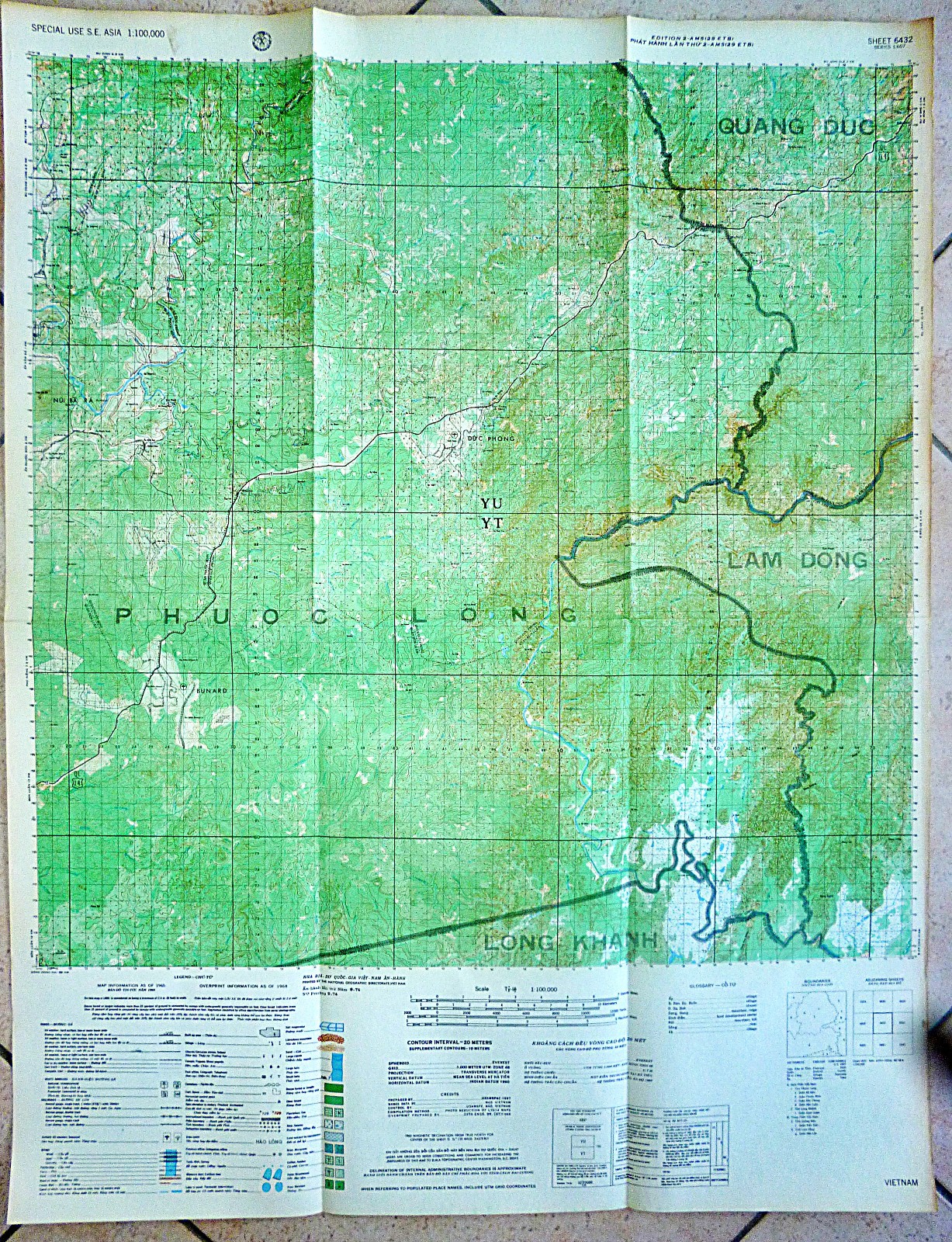
Vietnam War - US Military Map - Compiled 1968 - Printed December 1971Very Rare, Special Use Map - Series L607 - Vietnam / Cambodia Border
Prepared by US Army 29th EngineersControlled by USAMFE - Rare Piece
Cambodia–South Vietnam Border Region – Phước Long Province to Mondulkiri – 1968–1971
This map carries a United States Army overprint prepared in 1968 and was printed in December 1971. It depicts one of the most sensitive sectors of the Cambodia–South Vietnam border, extending from Phước Long Province westward into Mondulkiri Province, Cambodia. By the time this edition was printed, the military significance of the area had changed considerably following the expansion of Allied operations into Cambodia during 1970.
Throughout the late 1960s, this frontier was one of the principal infiltration corridors used by the North Vietnamese Army (NVA) and Viet Cong (VC). Dense forest, mountainous terrain and limited road access allowed troops, weapons, ammunition and supplies to move between Cambodian base areas and South Vietnam. Numerous secondary tracks linked with the wider Hồ Chí Minh Trail logistics system and bypassed established roads and population centres.
Unlike much of South Vietnam, conventional military operations were only one aspect of activity in this region. Intelligence gathering, long-range reconnaissance, cross-border surveillance and unconventional warfare became defining features of the frontier. United States Army Special Forces, MACV elements, Civilian Irregular Defense Group (CIDG) forces and other classified military organisations operated from isolated camps positioned along Highway 14 and the border districts. Their primary roles included reconnaissance, intelligence collection, monitoring infiltration routes and directing air and artillery strikes against identified enemy movements.
Bù Gia Mập Special Forces Camp occupied a strategic position near the Cambodian border in Phước Long Province. Although military mapping in 1968 identified the installation as abandoned, the area again became operational during the following years as Allied activity intensified along the frontier. Its location provided observation over recognised infiltration routes entering South Vietnam from eastern Cambodia. The camp supported reconnaissance patrols, border surveillance and intelligence operations directed into remote jungle areas.
Further north, Bù Prang Special Forces Camp occupied one of the most important positions on Highway 14. The camp overlooked approaches leading from Cambodia into Quảng Đức and Phước Long provinces and became a focal point for repeated North Vietnamese attacks. Its airstrip enabled continuous resupply, casualty evacuation, troop movement and reconnaissance support, particularly when road communications were interrupted.
Bù Krak Combat Base formed another forward operating location supporting military activity in the border region. The installation included an airstrip capable of supporting light transport aircraft and helicopters, allowing personnel, ammunition and supplies to be delivered directly into an otherwise isolated operational area. The base supported patrol operations, surveillance and rapid reaction forces operating along nearby infiltration corridors.
Military posts including Kiến Đạo, Đôn Long and Ô Rang extended the government presence beyond the larger Special Forces camps. These smaller installations provided local security, communications, observation and logistical support while serving as staging points for patrols operating into the surrounding forests. Ô Rang also contained military medical facilities supporting operations conducted throughout the district.
Across the international boundary, Mondulkiri Province remained one of the least populated regions of Cambodia. Its dense forests, limited infrastructure and proximity to South Vietnam made it an important rear area for North Vietnamese and Viet Cong forces. Base camps, supply depots, training areas and command facilities were established throughout the province, often beyond the reach of routine South Vietnamese ground operations prior to 1970.
Following the Cambodian Incursion of 1970, United States and Army of the Republic of Vietnam (ARVN) forces operated openly within parts of eastern Cambodia. Temporary forward operating bases, helicopter landing zones, artillery positions and logistics sites were established to support operations against communist base areas. Airfields and existing clearings were expanded where required to sustain helicopter and fixed-wing operations. These positions were intended to support military operations inside Cambodia and to disrupt the established communist logistics system supplying forces operating in South Vietnam.
Dak Dam, located within Mondulkiri Province, occupied a strategic position on routes leading east toward the Vietnamese border. The surrounding area was used by both communist and Allied forces during operations following the Cambodian Incursion, with its road network and high ground providing access between border districts and interior base areas.
Throughout this region, aerial reconnaissance formed an essential component of military operations. Observation aircraft, helicopters and tactical reconnaissance platforms monitored roads, jungle clearings, river crossings and suspected infiltration routes. Intelligence collected from aerial observation, long-range reconnaissance patrols, radio interception, captured documents and local reporting was combined to identify supply movements and locate communist base areas.
By late 1971, the military landscape depicted on this map reflected a border zone where conventional military operations, Special Forces activity, reconnaissance, intelligence collection and cross-border operations occurred alongside major North Vietnamese logistical movements. Highway 14, the Special Forces camps at Bù Gia Mập and Bù Prang, the forward facilities at Bù Krak, the military posts at Kiến Đạo, Đôn Long and Ô Rang, and the approaches into Mondulkiri formed part of one of the most active operational sectors along the Cambodia–South Vietnam frontier during the latter years of the Vietnam War.
Vietnam War MAP
- Measures - 29 x 22.5 inches (74 x 59 cms)