 1930 National Geographic Louisiana Map Vintage New Orleans Inset Original For Sale
When you click on links to various merchants on this site and make a purchase, this can result in this site earning a commission. Affiliate programs and affiliations include, but are not limited to, the eBay Partner Network.

1930 National Geographic Louisiana Map Vintage New Orleans Inset Original:
$24.99
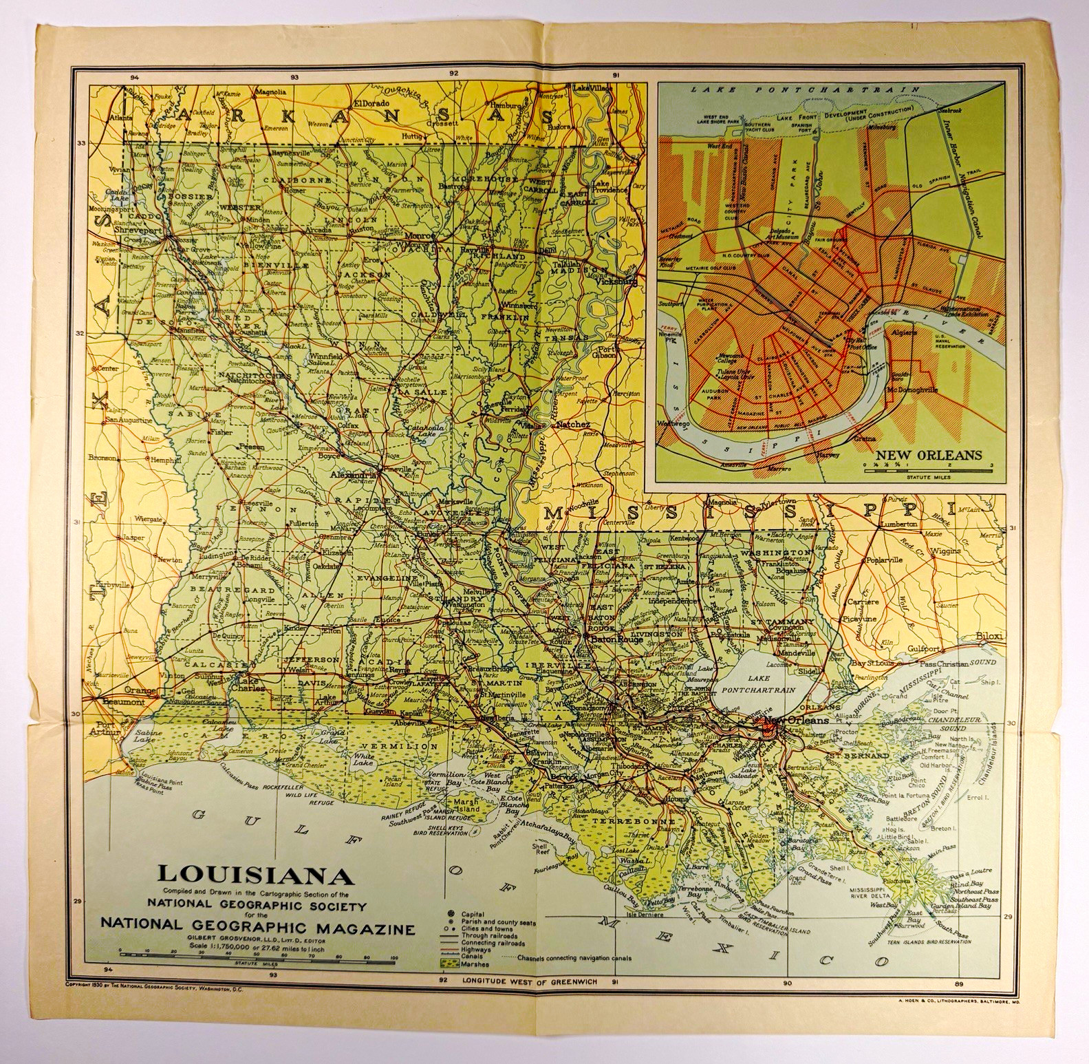
Offered for sale is an original vintage 1930 map of Louisiana, compiled and drawn by the Cartographic Section of the National Geographic Society for National Geographic Magazine.This beautifully detailed, full-color map provides a fascinating look at Louisiana as it appeared in 1930, featuring historic cities, towns, highways, railroads, waterways, parish boundaries, and geographical landmarks.A particularly interesting feature is the detailed inset map of New Orleans, showing the city’s historic street layout, Mississippi River, Lake Pontchartrain, and surrounding neighborhoods.Map Details:* Title: Louisiana* Publisher: National Geographic Society* Copyright: 1930* Cartographer: National Geographic Society Cartographic Section* Lithographer: A. Hoen & Co., Baltimore, Maryland* Dimensions: Approximately 13 x 13 inches* Scale: 1:1,750,000 (27.62 miles per inch)* Format: Original folded paper map* Special Feature: Detailed New Orleans city inset* Original vintage publication, not a modern reproductionHistorical Interest:This map captures Louisiana during the early 20th century, with detailed representations of New Orleans, Baton Rouge, Shreveport, Lake Charles, Alexandria, Lafayette, and numerous smaller communities.The map also illustrates the Mississippi River Delta, Gulf Coast, wetlands, lakes, canals, and transportation networks as depicted in 1930.An appealing piece for collectors of antique and vintage maps, Louisiana history enthusiasts, New Orleans collectors, genealogists, and anyone interested in historical cartography.Condition:Good vintage condition for its age, with visible signs of handling, storage, and use.* Original fold lines and associated creasing* Age-related yellowing and toning, particularly along the margins* Small tears and splits along portions of the outer edges and fold intersections* Minor edge curling and handling wear* Some discoloration, spotting, and soiling, particularly on the reverse* Handwritten identification and date on the reverse* Attractive original colors and generally clear, legible map details* No large missing sections apparentThe map is approximately 96 years old and is being offered in its existing vintage condition. It has not been professionally restored or conserved.Please carefully examine all photographs, including close-ups of the edges, fold lines, and reverse, as they are an important part of the description and accurately represent the map’s condition.Shipping:The map will be carefully packaged to help protect it during shipment. It will be shipped folded along its existing fold lines.A wonderful piece of Louisiana and New Orleans history, suitable for collecting, historical research, or framing.
|
|
Other Related Items:
Related Items:
1930 National Geographic Louisiana Map Vintage New Orleans Inset Original $24.99

Vintage The National Tyres With International Reputation Enamel Sign Board EB23 $147.50
1930 National Tube Ad: Hotel Lexington, New York City - Nice Artist's Rendering $21.84
|